
Stories from the Viewer
Read stories and learn facts about New Hampshire’s coast using data and maps from the NH Coastal Viewer. Get ideas for how to use the Viewer to explore your own questions about coastal New Hampshire.
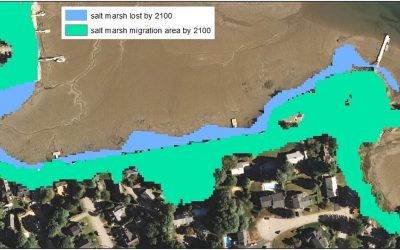
The Story of the Marsh that Moved
Map info: The map shows existing (2014) salt marsh along New Castle Avenue in Portsmouth NH and area where marsh would hypothetically migrate to by 2100 assuming a high scenario of 2 meters of sea-level rise and no barriers (walls, road) impeding migration. Map...
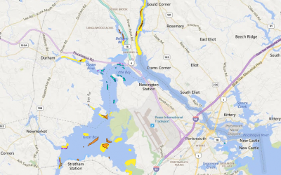
Oysters: Bivalves with Lots to Give
Map info: This map shows oyster area lost since 1982 (yellow), existing natural oyster beds (orange), oyster restoration areas (purple), and oyster farms (turquoise). Map created by Kirsten Howard in October 2015 using the NH Coastal Viewer. Coastal Viewer data layers...
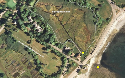
A New Look for an Old Culvert at Bass Beach
Map info: Bass Beach and Farragut Marsh (outlined in white), divided by Route 1A. The yellow dots mark the approximate location of the culvert, where water flows between the beach and marsh under 1A. Map created by Brendan Newell on 6/29/15 using the NH Coastal...
Got a story idea?
We’d love to feature maps made by NH Coastal Viewer users to answer questions, display interesting data, and better understand coastal New Hampshire.